Hard work, passion goes into producing annual waterfowl report
Published 10:00 am Saturday, October 5, 2024
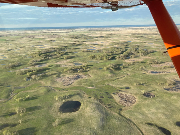
- Prairie pothole habitat on the border of Saskatchewan and Manitoba.(Courtesy Photo | United States Fish and Wildlife Service)
BANGOR, Maine — A lot of work goes into producing the United States Fish and Wildlife Service publication summarizing the breeding populations of waterfowl. The report is of importance to any waterfowl hunter because they are used to inform hunting regulations for waterfowl in coming seasons.
Migratory Bird Surveys Branch Chief Mark Koneff oversees the legwork needed to produce such an important report each year. His 11 survey air crews fly 330 transects in the traditional survey area over a month’s span in the spring. In the fall, his work resumes as he must plan for the next year.
“We don’t have staffing for all of the positions. Regions contribute qualified individuals. I have to write a memo requesting participation,” Koneff said. “It starts now for the next May survey. Over the Winter, we can’t just go into Canada and work up there. We have to work with them and they submit a formal invitation to us every winter. I will coordinate with our embassy in Ottawa. We have to get flight clearances for aircraft so we can enter foreign air space.”
Trending
At the same time, Koneff is working with the USFWS regions to confirm crews and backups. He must work with Canada customs for entry and request exemptions on any visa fees. In Canada, they must maintain liability insurance for foreign nationals and means of recovery if something goes wrong. According to Koneff, the United States government is self insured.
Some areas require permits for any overflight work and they must meet with Canada’s First Nations communities. Next, Koneff handles crew level planning and work starts for laying out flight plans and logistics. Crews go through a lot of training through the late winter and review the standard operating procedures. They must understand how to use aircraft for recording data. It then takes a month and a half to conduct the survey and an additional month to clean up the data on the survey crew end.
“After we transmit data there is work done to get the estimate out. All of our branches pull together. It is a team effort those last few weeks or so. We proofread and check every number. It is quite a push to get it out the door,” Koneff said. “I have people who now do more detailed reviews than I do. I read it to make sure it captures the habitat conditions we saw. It is a fairly good size team that conducts that final review. I take a lot of satisfaction in it. I’m privileged. Pioneers in our field who got this survey up 70 years ago to get it where it is today. To have been a part of it for 30 years now for me, I feel a little bit of pride and responsibility. I want to make sure it does well.”
Conducting the survey
In conducting surveys, the longer flight transects are 300 miles in length with 250 miles being the average length of a transect with a few that are smaller. Transect lines are not entirely straight, instead they curve with the minutes of longitude and latitude along a circular path. Crews fly transects using greater circle navigation to account for the curvature of the Earth. In the prairies of Canada, where a lot of Mississippi’s ducks come from, crews fly on a PLS system following secondary gravel roads.
All of the survey work is done from 150 feet above the ground. Accounting for the quarter mile width of transects, crews see 9,600 square miles of the 1.3 square miles of land in the traditional survey area.
Trending
Surveyors go through extensive training to be able to identify birds in the surveys. New surveyors start out with manuals and videos and are tested on the training. Once they master identification in a controlled setting, they start to take the back seat in the survey plane and talk about what they see with the front seat observers to compare observations.
“You learn to apply different cues. Sometimes you are looking at patterns and the habitat and how they act. There are a bunch of factors you have to know and it takes a number of years to get confident at it. Even experienced birders might not have mastered the overhead perspective of surveying for birds.”
Koneff said five crews also work on the ground surveying in the Canadian prairie where they can spend more time and scope out the wetlands. Land surveyors have a better view of the birds and the data they collect are used to scale the aerial counts.
In the plane, Koneff said decades ago they were using tape recorders to document surveys. Now, crews use a specially designed computer where it records their audio observations and GPS data. The computer is more stable and the software is able to transcribe observations and match it with the GPS points which is much quicker.
Koneff said they use a standard cadence and sequence in recording observations which is species, social grouping and count. The reason for this is because sometimes an observer starts talking as they push the record button and may not record the initial portion of the entry but it is easier to determine the species from a partial recording.
For example, if all you hear in a recording is “ard,” the observer knows it is a mallard. “Ail,” would be a pintail. While it is not entirely foolproof, it tends to be a better buffer against human error.
Prairie surveys follow a different procedure than flights conducted over boreal forests. Koneff said flights leave early in the morning in the prairie region while over forests they wait until midday so they don’t have any issues with shadows.
Before planes ever take off, crews monitor the weather and make sure they have flight plans ready with other alternatives. Crews preflight the airplane, brief the observer, plan any fuel stops and then conduct post flight maintenance upon return. Technology has allowed the crews to utilize a central dispatch for flight plans and updates. Planes are also tracked using GPS technology.
“It is a bit different than it used to be. They just went up until they came home,” Koneff said. “A few years ago, we started to know generally where people were. We have automated tracking now that in the event of a mishap we can get search and rescue crews out.”
At the end of the day, workers transcribe data and email it off. There are some days where weather does not allow for flying or observation so crews get a break.
A true passion
It can be taxing work but Koneff said people who do stick with it have a passion for the resource. It is a passion for flying and wildlife which led Koneff to working for the United Fish and Wildlife Service.
He said he wanted to go into the Air Force to become a pilot and had an ROTC scholarship. His eyes were tested and he had astigmatism which was enough to bump him out of the pilot seat. Koneff said he decided to focus on wildlife management in college instead. He learned he could do both wildlife management and flying.
“That is where I started to tailor my graduate work toward waterfowl and wetlands. I was most interested in migratory birds, the history of migratory birds and how they are continental in scale. It was all really interesting to me,” Koneff said. “I was in a PhD program when one of my former professors let me know a position opened up. I applied for the job and got selected. I worked as a waterfowl biologist until I could pursue the aviation side. I had my basic credentials. They picked me up and supplied more advanced training.”
Koneff said he will always be partial to sea ducks. Scooters, eiders, buffleheads, golden eyes and mergansers are what he grew up seeing along the Atlantic Coast. He has lived along the coast of Maine where he owned layout boats to hunt diving ducks in.
Koneff said he has worked on offshore surveys for sea ducks with other agencies and has really grown to love them. Sea ducks have a hardiness and live in a different environment.
“Watching those birds come in low while you are in a boat takes you back to what it was like 100 years ago,” Koneff said. “I still enjoy smaller creek hunting. I enjoy the colors of wood ducks and I get the occasional mallard.”


-
Polls
 Loading ...
-
-