Dangerous heat stress conditions return
Published 12:30 pm Monday, July 29, 2024


BROOKHAVEN — People may rejoice the return of sunshine but a trade off is the return of dangerous heat stress conditions. National Weather Service in Jackson warns the heat stress conditions could persist until Saturday.
NWS Jackson warns temperatures will be in the mid to upper 90s this week with heat indices being 106 to 110. Heat exhaustion is likely with prolonged outdoor activity. Heat stress conditions will occur between 10 a.m. and 7 p.m. each day.
At this time, Lincoln County is under a heat advisory until 7 p.m. NWS Jackson advises area residents to drink plenty of water, stay in air conditioned rooms, stay out of the sun and check on family and neighbors.
Trending
“Take extra precautions when outside. Wear lightweight and loose fitting clothing,” NWS Jackson warns. “Try to limit strenuous activities to early morning or evening. Take action when you see symptoms of heat exhaustion and heat stroke.”
Wednesday, Friday and Saturday are all forecast to have highs of 97 degrees.
Rainfall record
Saturday was the last day of measurable rainfall ending a consecutive rainy day streak at 10 days. The figure will place in the top 10 consecutive days of measurable rainfall.
According to NWS Jackson records, the longest consecutive streak of rainy days was 13 ending on June 27, 1983. July 2024’s streak of 10 days of measurable rainfall is tied for 7th place in the top 10. The figure ties 10 day consecutive streaks ending on January 17, 2013 and February 2, 1902.
Hurricane forecast
Trending
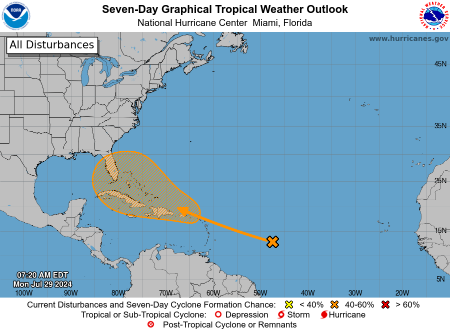
National Hurricane Center in Miami, Florida forecasts the chance of a tropical cyclone forming in the next seven days improved from 20 percent to 50 percent. According to the forecast graphics, a disturbance in the tropics is currently located near the leeward islands in the Caribbean Sea. Tropical cyclone formation chances improved for the disturbance as it nears an approaching tropical wave in the area.
“Environmental conditions are forecast to become conducive for some development thereafter, and a tropical depression could form later this week while the system is in the vicinity of the Greater Antilles or the Bahamas,” NHC states.


