Future of the Pearl River as important as its past
Published 3:00 pm Friday, December 6, 2024


By ERNEST HERNDON
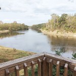
When you stand on the deck at Cooper’s Ferry Park in Monticello and look out over the Pearl River, it’s easy to think about the past — especially when the occasion is a meeting of the Lawrence County Historical Society.
I was guest speaker for the group in November, my topic being the new book “Paddleways of Mississippi” I coauthored with Patrick Parker.
Trending
These Lawrence County folks are passionate about the Pearl, and it’s easy to see why: It passes barely a block north of downtown.
The historical society members are especially concerned about the possible effects of the proposed One Lake project in Jackson.
The plan, which has proceeded in fits and starts for years, has drawn opposition from a long list of organizations as well as towns and counties downstream — including Monticello.
Former state capital
Cooper’s Ferry Park is located at the “original site of the foundation for the Town of Monticello which began with Samuel Cooper’s ferry crossing in 1812 connecting the east and west corridors of St. Stephens Road, now known as Highway 184,” according to the town website.
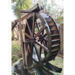
The small city park features a gazebo, an elevated boardwalk trail through the trees, a functioning wooden water wheel and, best of all, the huge deck overlooking a long stretch of the Pearl and the Highway 84 bridge to the north.
Trending
St. Stephens Road, constructed in 1806-1811, “was a main wagon and trade route connecting Natchez through the Mississippi Territory with Fort St. Stephens in Alabama,” according to a state historical marker in Brookhaven.
In many ways Monticello — which was the state capital before Jackson — was more developed in the early 1800s than it is now, according to some old newspaper articles given to me by society member Wilson Farnham.
“It was the center of large plantations, the homes of scores of wealthy people,” said the June 30, 1892, Lawrence County Press.
A trip downriver
An article in the April 18, 1895, edition described a steamboat trip down the Pearl from Monticello to its mouth at Lake Borgne, through the Rigolets and across Lake Pontchartrain to New Orleans.
The lower Pearl River splits into a maze of channels, one of which is Holmes Bayou.
“The bayou is seven miles in length and contains 72 bends,” said the article by “Ye Editor.”
On the West Pearl River, “the run to the mouth, 12 miles, one sees the most crooked, and in some parts most narrow, river in the United States,” the article said.
“In some places it is so narrow that one can step off on either bank while the boat is under full headway, kill as many squirrels as he can carry, get bitten by an alligator, and then step across the country about a quarter and then catch the boat, which has, during this time, traversed a mean distance of 14 2/3 miles.”
The article described the surroundings as “cane-brakes, immense forests and impenetrable undergrowth of every description.”
Having canoed through this swamp, I can attest it’s just as wild and tangled as ever.
Past, present and future
At the historical society meeting, president Alicia Reynolds outlined various organization projects, such as the purchase of the old town depot.
The society has numerous fundraisers, including its own thrift store, and a cookbook titled “A River and a Road” with historical photos and write-ups. Local folks also donate generously — such as a contractor who offered to re-roof the depot for free.
During the question-and-answer part of my talk, the audience focused on the Pearl, of course — and the One Lake project. Monticello Mayor Martha Watts leads the fight against it for her town and said every time she thinks the project is dead, it resurfaces.
When it comes to the Lawrence County Historical Society, the future of the Pearl is every bit as important as its glorious past.
This story first appeared in The Enterprise-Journal.


