Francine makes landfall, weather impacts on the way to Lincoln County
Published 5:11 pm Wednesday, September 11, 2024
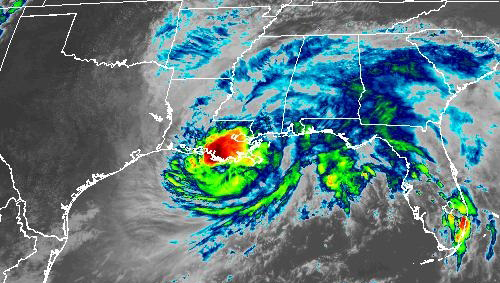
- Hurricane Francine makes landfall in Terrebonne Parish in Sept. 2024. (Courtesy Photo | National Weather Service)
BROOKHAVEN — Hurricane Francine officially made landfall in Terrebonne Parish Wednesday afternoon at 5 p.m. The storm was a category 2 hurricane with 100 mph sustained winds. A weather station on Eugene Island recorded 105 mph wind gusts.
Lincoln County is expected to experience wind gusts of 45 to 55 mph which could lead to widespread downed trees and power lines. Damage to roofs and roads being blocked could be expected. Power outages could last for several days. An onset of strong winds is expected to be in the area between 12 a.m. and 8 a.m. Thursday.
Flash flooding is also a threat associated with this storm. Francine could dump four to six inches of rain on Lincoln County in a short period of time causing localized flash flooding of low lying areas and minor river flooding. There is also a marginal risk of tornados developing in a majority of Lincoln County but the tornado threat has really shifted towards Alabama.
Trending
As of this morning, a tropical storm warning and flood watch were in effect. A tropical storm warning means tropical storm winds are expected in the next 36 hours. Severe weather is forecast to pass through by commute time Thursday morning but it will depend on tree and power line damage how safe a morning commute would be.
The Brookhaven Building, located at 1154 Beltline Drive in Brookhaven, will be open as a safe room starting at 3 p.m. People would need to bring their own medication, food, water, comfort items and any other necessary items with them. Chairs and tables would be provided. Pets are not allowed in the safe room. It will remain open as a safe room until the threat of severe weather is over.
Check back for more updates as this storm approaches southwest Mississippi.
Trending


-
Polls
 Loading ...
-
-